
Vágar · on foot, without a car
Sørvágsvatn and Trælanípa by bus: the lake above the ocean without a car
Last checked: 19 September 2026
The short answer
Route 300 — the airport bus — stops at Miðvágur, and the trailhead is there. Of all the famous Faroese walks this is the one the scheduled network handles best, because it sits on the trunk corridor rather than at the end of a branch.
Getting there: Route 300 from Tórshavn or from Vágar Airport; get off at Miðvágur. It is the same all-week bus most visitors already take in from the airport.
Source: Strandfaraskip LandsinsRoute 300 Tórshavn – Airport – SørvágurTrælanípan (landowner)Trælanípan and Bøsdalafossur — hiking options and pricesVisit Faroe IslandsHiking fees — routes that charge for access or require a guide
Before you go
This walk crosses private land and charges for access
- Adult
- 200 DKK without a guide; a private guided walk is 600 DKK a person, minimum five
- Concessions
- Children up to 15 free
- Guide
- Not required
The landowner's own prices, which differ from the tourist board's list. Walking alone needs no booking: pay at the coffee shop at the start, by card or cash. A guided walk must be booked at least two days ahead.
These are the amounts Visit Faroe Islands publishes. The landowners set them and change them, so treat the official list as the authority rather than this page.
Source: Visit Faroe IslandsHiking fees — routes that charge for access or require a guide
The transport
Reaching the trailhead
Route 300 from Tórshavn or from Vágar Airport; get off at Miðvágur. It is the same all-week bus most visitors already take in from the airport.
- Trailhead
- Miðvágur, where the landowner's reception and gate are
- Car-free verdict
- Bus to the village, then walk
Bus 300 — Tórshavn – Airport – Sørvágur
Sources: Strandfaraskip LandsinsRoute 300 Tórshavn – Airport – SørvágurTrælanípan (landowner)Trælanípan and Bøsdalafossur — hiking options and pricesVisit Faroe IslandsHiking fees — routes that charge for access or require a guide
The part that decides the day
Getting back
The gentlest return on this list: you walk back to the same bus stop on a corridor with all-week service. It is still a published timetable rather than a frequent one, so read the return column before you set out.
We do not publish departure times: the operator reissues them several times a year and a stale last bus here is the one error on this site that could leave somebody on a mountain. Every route linked above goes straight to its own official timetable.
The walk itself
What the ground is like
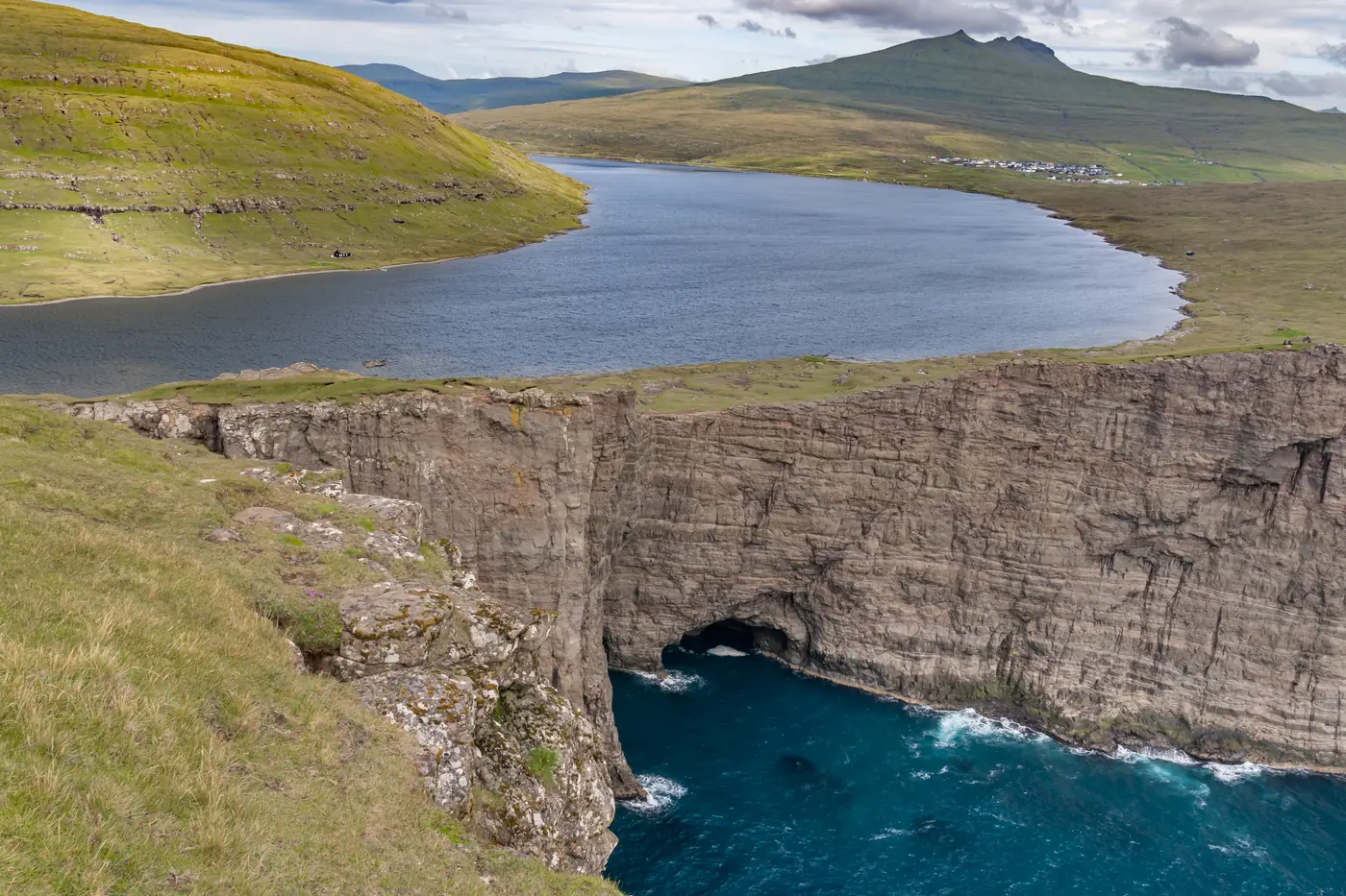
A marked trail of 3.5 km each way to the cliff edge at Trælanípa, where the optical illusion that fills the postcards appears — the lake reads as though it hangs high above the sea. The landowner puts it at about 45 minutes each way, though most people take two and a half to three hours with photo stops. Bøsdalafossur, where the lake empties over the cliff into the Atlantic, is a little further on. The landowner says the path along the lake itself is currently closed for bird protection, so follow the marked trail.
Visit Faroe Islands advises against hiking between 2 November and 31 December, the hare-hunting season, and asks anyone who does to contact the landowner first.
Source: Visit Faroe IslandsHiking in the Faroe Islands
About that photograph
Trælanípan is a rock wall that Visit Faroe Islands measures at 142 metres above the sea. The famous picture makes Sørvágsvatn look as though it is suspended hundreds of metres up, tipping towards the ocean.
It is perspective. The photograph is taken low and from the south, so the near clifftop rises in the frame and the far surface of the lake sits behind it — the water is only a little above sea level. Knowing that does not spoil it. It does mean you should walk to the right spot rather than wondering why the view from the path looks ordinary.
The trailhead is at Miðvágur, which route 300 — the airport bus — stops at all week.
Source: Visit Faroe IslandsTrælanípan
Experiences
Guided walks and transfers
When the timetable does not reach the trailhead on your dates, a guided trip brings its own transport. These are live listings for the islands.
Some links on this page are affiliate links. If you book through one we may earn a commission, at no extra cost to you. It never changes what we tell you about the buses and ferries, and no operator pays for a place on this site.
Next